The Most Scenic UK Drives: 10 Beautiful Routes for 2026
James has been writing about UK roads, traffic law, and vehicle regulation for over 8 years. He holds a full UK Category B licence and has driven extensively on the UK motorway network.
The UK punches well above its size when it comes to scenic driving. Within this relatively small island, you can drive through Highland mountain passes, along wild Atlantic coastlines, across rolling limestone hills, and through ancient forests — all without leaving the country. This guide covers ten of the most spectacular driving routes in Britain, with practical information on distance, timing, road conditions, fuel stops, and tolls.
1. North Coast 500, Scotland
Often called "Scotland's Route 66," the North Coast 500 is a 516-mile circular route starting and ending in Inverness that traces the dramatic northern and western coastline of the Scottish Highlands. Launched as a branded tourism route in 2015, it has since become one of Europe's most celebrated road trips.
| Distance | 516 miles (circular from Inverness) |
| Recommended time | 5–7 days minimum; 10 days for a relaxed pace |
| Best season | May–September (many businesses close November–March) |
| Road type | Mostly single-track A and B roads — allow significant time |
| Tolls | None on the main NC500 route |
The route covers some of the most dramatic and remote landscapes in the British Isles. Clockwise from Inverness, highlights include: the Black Isle, Dornoch and Dunrobin Castle on the east coast; the very top of mainland Britain at Dunnet Head and Durness in the north; the wild Atlantic coast through Torridon and the Applecross Peninsula on the west; and the fairy pools of the Isle of Skye nearby (worth a detour via the toll-free Skye Bridge).
Practical note: the NC500 is largely single-track road. You must use passing places correctly — pull into the left-side passing place to let oncoming vehicles through; never pull to the right. Journey times are significantly longer than distance would suggest: 50 miles on the NC500 may take 2–3 hours. Fuel up whenever you have the opportunity — petrol stations can be 50+ miles apart in the far north.
2026 Visitor Note
The NC500's popularity has grown significantly since its launch. In peak July and August, some sections can be congested and accommodation books out months in advance. Consider travelling in May, June, or September for better availability and fewer midges (the biting insects that plague the Highlands in midsummer).
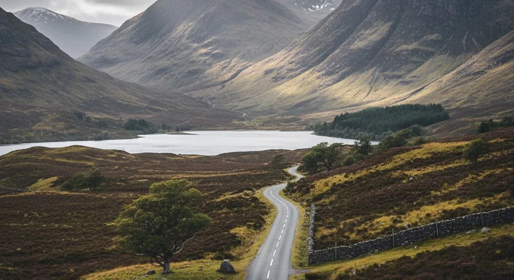
2. The Applecross Peninsula and Bealach na Bà
Not technically part of the NC500 but close to it, the Bealach na Bà ("Pass of the Cattle" in Gaelic) is one of the most dramatic mountain road drives in Britain. It climbs from sea level to 626 metres (2,054 feet) in under 6 miles, with hairpin bends, sheer drops, and views that on a clear day extend to the Outer Hebrides and across to Skye.
| Route | Tornapress to Applecross village |
| Distance | ~12 miles over the pass |
| Warning | Not suitable for large vehicles or caravans; closed occasionally in severe winter weather |
| Tolls | None |
The road is single-track with limited passing places on the steepest sections. Drive the pass early in the morning or late evening in summer to avoid the worst of the tourist traffic — and to catch the golden light on the peaks. The village of Applecross on the other side has a famous seafood pub (the Applecross Inn) serving fresh langoustines caught from the bay.
3. Lake District: Kirkstone Pass and Ullswater Valley
England's highest mountain pass road, Kirkstone Pass (A592) connects Ambleside with Ullswater, climbing to 1,489 feet through some of the most dramatic fells in the Lake District National Park. The road is steep and narrow in places but well-surfaced and passable in most conditions.
| Route | Ambleside → Kirkstone Pass → Brothers Water → Ullswater |
| Distance | 15 miles (extend to Penrith for a 25-mile route) |
| Best season | Spring (lambs in the fields), autumn (fall colours) |
| Winter note | Gritted but can be icy; the Pass is occasionally closed in heavy snow |
| Tolls | None |
The Kirkstone Pass Inn at the summit is one of England's highest pubs (open to visitors; highly recommended for warming up after a walk). Descending northwards into the Ullswater valley, the road hugs the western shore of the lake with views across the water to the fells on the opposite bank. The steamer services on Ullswater provide an alternative return leg if you'd prefer to extend the day.
4. Snowdonia: The A4086 Llanberis Pass
Wales's highest mountains are spectacular when driven through rather than just glimpsed from a distance. The A4086 through the Llanberis Pass runs beneath 1,000-metre peaks with glacially-carved cwms (hanging valleys) on either side, past the slate mining heritage of Llanberis and towards the castle town of Caernarfon on the Menai Strait.
| Route | Betws-y-Coed → A5 → Llanberis → A4086 → Caernarfon |
| Distance | 30 miles |
| Highlights | Snowdon/Yr Wyddfa summit access, Llanberis slate museum, Caernarfon Castle (UNESCO World Heritage) |
| Tolls | None on main route; Conwy Tunnel has no charge |
The Snowdon Mountain Railway runs from Llanberis to the summit of Wales's highest peak — worth booking in advance in summer if you want to take it. For drivers, the Pen-y-Pass car park at the top of the Llanberis Pass is the starting point for two of Snowdon's most popular walking routes (pre-booking essential in summer due to capacity limits on the car park). Caernarfon's 13th-century castle, built by Edward I, is one of the most impressive medieval fortresses in Europe.
5. The Cotswolds Circular
For a gentler but equally beautiful drive, the Cotswolds Area of Outstanding Natural Beauty offers honey-coloured limestone villages, rolling hills, and quintessentially English countryside that looks almost unchanged from the 17th century. The Cotswolds sit astride the counties of Gloucestershire, Oxfordshire, Warwickshire, and Wiltshire.
| Route | Burford → Bourton-on-the-Water → Stow-on-the-Wold → Chipping Campden → Broadway → Moreton-in-Marsh → return |
| Distance | ~60 miles circular |
| Best season | Spring (daffodils), summer (gardens open), autumn (foliage) |
| Tolls | None |
Bourton-on-the-Water is famous for the stream running through its village green, though it can be very busy in peak summer. Stow-on-the-Wold sits at the highest point of the Cotswold plateau and has excellent antique shops and pubs. Chipping Campden's High Street is regarded as one of England's most beautiful market streets. Broadway Tower, on a prominent hilltop outside the village of Broadway, offers views across fourteen counties on a clear day.
6. Jurassic Coast, Dorset
England's only natural UNESCO World Heritage Site stretches 95 miles along the Dorset and East Devon coast, exposing 185 million years of geological history in its sea cliffs. The coastal road is not a single continuous route but a series of connected A and B roads that allow close access to the most dramatic sections.
| Route | Lyme Regis → Bridport → Abbotsbury → Weymouth → Lulworth Cove → Swanage |
| Distance | ~50 miles (western section) or full 95 miles from Exmouth |
| Highlights | Durdle Door, Lulworth Cove, Chesil Beach, Corfe Castle, Old Harry Rocks |
| Tolls | None on main roads; Sandbanks Ferry (car ferry across Poole Harbour mouth) ~£5 for car |
Durdle Door — a natural limestone arch leading into a sheltered cove — is one of England's most photographed coastal landmarks. Lulworth Cove is a perfect circular cove where the sea broke through a band of harder limestone and carved the softer chalk behind it. Chesil Beach is an 18-mile barrier beach of graded pebbles — larger stones at the Portland end, smaller at the Bridport end — still not fully understood by geologists. Corfe Castle, a ruined 11th-century fortress on a natural hill, guards the only road into the Purbeck peninsula and is visible for miles.
7. Peak District: Snake Pass and Hope Valley
The A57 Snake Pass between Sheffield and Glossop is one of England's most dramatic moorland roads — a high-level crossing of the Peak District that lives up to its name with tight bends and exposed moorland. Combined with the Hope Valley below, it forms a loop that showcases two entirely different characters of the same national park.
| Route | Sheffield → A57 Snake Pass → Glossop → A624 to Castleton → Hope Valley → A6013 → return to Sheffield |
| Distance | ~60 miles circular |
| Highlights | Ladybower Reservoir, Mam Tor, Castleton (Blue John caverns), Edale |
| Warning | Snake Pass is frequently closed in winter due to snow — check before travelling November–March |
| Tolls | None |
Ladybower Reservoir is particularly dramatic: a Y-shaped reservoir with two drowned villages beneath its waters, and famous for the bouncing bomb trials conducted over its surface during World War II (it was the target lake used to test the Dambusters' bomb before the real raids). Mam Tor near Castleton is known as "the shivering mountain" for its unstable hillside — the old A625 road across it was repeatedly destroyed by landslips and eventually abandoned in 1979.
8. The Isle of Skye and the Road to the Isles, Scotland
Skye is reached via the toll-free Skye Bridge from Kyle of Lochalsh — no ferry required since 1995. The island's dramatic scenery of jagged black Cuillin mountains, the Quiraing rock formations, and the Old Man of Storr make for some of Britain's most distinctive driving landscapes.
| Route | Fort William → A830 (Road to the Isles) → Mallaig → ferry to Armadale, Skye → circular of Skye → Skye Bridge → return via A87 |
| Distance | ~200 miles including Skye circular |
| Best season | May–September; October for autumn colour |
| Tolls | Skye Bridge — no toll (removed 2004). Mallaig–Armadale ferry: car + driver ~£25 return |
The A830 from Fort William to Mallaig — the "Road to the Isles" — passes Glenfinnan Viaduct, which film fans know as the Hogwarts Express viaduct from the Harry Potter films. The Jacobite steam train still runs this route in summer (book months in advance). On Skye, the Quiraing in the north of the island is a landscape unlike anywhere else in Britain — tilted lava plateau with pinnacles, cliffs, and hidden pools. The Fairy Pools on the western slopes of the Cuillin are a series of clear-blue mountain pools connected by waterfalls.
9. Pembrokeshire Coast, Wales
Pembrokeshire in southwest Wales has the UK's only coastal national park. Its B-roads run close to cliffs, coves, and harbours along a coastline that was sculpted by Ice Age glaciers and is now home to abundant wildlife — seabirds, grey seals, and dolphins are all regularly sighted from coastal viewpoints.
| Route | Cardigan → Newport → Fishguard → St Davids → Pembroke → Tenby → Saundersfoot |
| Distance | ~80 miles |
| Highlights | St Davids Cathedral (smallest city in Britain), Pembroke Castle, Barafundle Bay, Stackpole Quay |
| Tolls | None (Cleddau Bridge toll removed 2018) |
St Davids is technically a city (because it has a cathedral) but with a population of only 1,800 — the smallest city in the UK by population. Its 12th-century cathedral is reached via steps that descend into a hollow — unusually hidden from the town centre. Barafundle Bay, accessible only on foot from Stackpole Quay (no road access), is one of Wales's most beautiful beaches and benefits from its inaccessibility by car.
10. Yorkshire Dales: the B6160 and Upper Wharfedale
The Yorkshire Dales National Park is characterised by limestone valleys, dry stone walls, field barns, and moorland that stretches to the horizon. The B6160 through Upper Wharfedale and into the remote valleys of Langstrothdale and beyond is one of northern England's finest drives.
| Route | Ilkley → Bolton Abbey → Grassington → Kettlewell → Buckden → Aysgarth Falls → Hawes |
| Distance | ~55 miles |
| Highlights | Bolton Abbey Priory, Kilnsey Crag, Aysgarth Falls, Hardraw Force waterfall, Hawes cheese factory |
| Tolls | None |
Bolton Abbey Priory ruins in the gorge of the River Wharfe provide a dramatic starting point. Kilnsey Crag — an overhanging limestone cliff that looms over the valley floor at Kettlewell — is one of northern England's most distinctive rock formations and a popular rockclimbing venue. Aysgarth Falls is a series of broad limestone steps where the River Ure cascades through a woodland gorge — the falls featured in Robin Hood: Prince of Thieves. Hawes is the highest market town in England and home to the Wensleydale Creamery, where you can watch Wensleydale cheese being made.
Planning a Scenic Drive: Practical Tips
Fuel on Remote Routes
Several of the UK's most scenic routes pass through areas with very limited fuel infrastructure. On the NC500, the Skye route, and the Pembrokeshire coast, petrol stations can be 30–50 miles apart. Remote Scottish stations often close on Sundays. Fill up at every opportunity on long remote drives — don't gamble on having enough to reach the next major town.
Tolls on Scenic Routes
The good news is that most of the UK's scenic routes are entirely toll-free. The main UK toll roads (M6 Toll, Dartford Crossing) are near urban centres and are unlikely to feature on purely scenic route planning. The Sandbanks Ferry on the Jurassic Coast route costs around £5 for a car and is worth taking for the experience and the time it saves on the outskirts of Bourton.
Single-Track Road Etiquette
Many of Britain's most scenic roads are single-track. Rules to follow:
- Slow down well before passing places — don't approach them at speed hoping the other driver will wait
- Passing places on your left are for you to pull into to let oncoming traffic through. Passing places on your right mean you should wait and let the other vehicle use the passing place.
- If a vehicle behind you wants to pass and there's a passing place ahead, pull in and let it past — don't make following vehicles match your pace
- Never block a passing place by parking in or near it
- Campervans and caravans require extra caution on these roads — they may take multiple attempts to negotiate tight passing points
Weather and Timing
UK weather is unpredictable, but the following general principles apply:
- Mountain passes (Bealach na Bà, Kirkstone, Snake Pass) can be closed in winter — check conditions before travelling October–March
- The west coasts of Scotland and Wales receive significantly more rainfall than the east — cloud and rain are more common on the NC500's western leg than its eastern coastal section
- Midges (biting insects) are a real nuisance in the Scottish Highlands from June to August, especially in still conditions around dusk. Carry repellent if stopping in woodland or near water in the evenings.
- Early morning and late evening light produces the most spectacular photography — many scenic routes are heavily trafficked at midday in summer
Calculate Your Journey Costs
Use our toll and fuel calculator to estimate the total cost of your scenic road trip — including any toll roads, fuel at current UK pump prices, and your vehicle's fuel type and efficiency.
Related Articles
Frequently Asked Questions
What is the most scenic drive in the UK?
The North Coast 500 (NC500) in Scotland is widely considered the most scenic drive in the UK and one of the top road trips in Europe. The 516-mile circular route starts and ends in Inverness and passes through some of the most dramatic Highland landscapes in Britain: the Torridon mountains, Cape Wrath, Smoo Cave, Dunrobin Castle and the far north coast. The route is best driven over 5–7 days to stop and explore rather than simply drive. It is completely free of tolls.
Are there any tolls on scenic UK drives?
Most scenic UK drives are toll-free. The North Coast 500 in Scotland has no tolls. The Jurassic Coast route, Cotswold Way drive, and most Welsh routes are also free. The main exceptions are if your route passes through the Dartford Crossing on the M25 (£2.50 for a car) or uses the M6 Toll to bypass Birmingham (£7.10 for a car). Scotland abolished all road tolls in 2008 — no bridges or tunnels in Scotland charge to cross.
When is the best time to drive the North Coast 500?
May to September offers the best weather and longest daylight hours for the NC500, with June and September typically offering the best balance of good weather and fewer crowds. July and August are peak season — campsites and accommodation fill months in advance, and single-track roads can become congested in popular areas. Spring (April–May) is excellent for wildlife and quieter roads. Winter driving on the NC500 requires experience with single-track roads and awareness of ice and snow on exposed Highland sections.
What is the most scenic coastal drive in England?
The A39 Atlantic Highway in Devon and Cornwall is the standout coastal drive in England — running close to the north Cornwall coast from Barnstaple to Penzance with sections passing dramatic sea cliffs, surfing beaches and fishing villages. Alternatively, the drive along the Jurassic Coast (A352 and A353 through Dorset) passes UNESCO World Heritage coastline including Lulworth Cove, Durdle Door and the Chesil Beach. Both routes are best driven outside school holidays due to summer congestion on narrow coastal roads.
Do I need a 4x4 for scenic UK drives?
No — the vast majority of popular scenic UK drives are accessible in a standard two-wheel-drive car, including the North Coast 500 and most routes in Wales, the Peak District, and the Cotswolds. A 4x4 is only beneficial if you are venturing onto unsurfaced tracks or forest roads off the main route, or driving in remote Highland areas in winter where snow or ice may be present before roads are treated. Single-track roads with passing places (common on the NC500) require care and courtesy but do not require four-wheel drive.