UK road signs follow a logical system of shapes, colours, and symbols that, once understood, allows you to decode almost any sign you encounter — even one you have never seen before. This comprehensive guide covers every category of UK road sign: the shape-based system that tells you the type of instruction at a glance, colour coding for different information types, the full range of warning, regulatory, and directional signs, road markings and their meanings, and the electronic signs unique to smart motorways.
The Three Shapes: The Foundation of the UK System
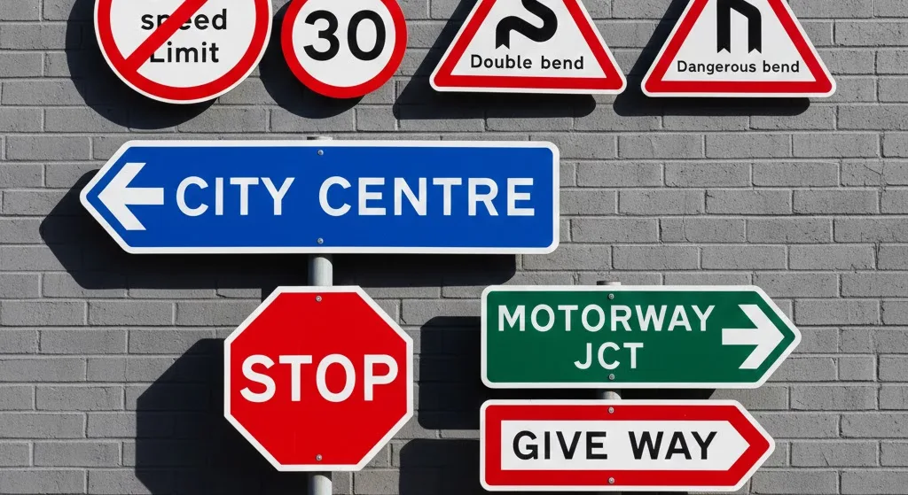
The most important aspect of UK road signs is their shape. The shape tells you the category of instruction before you have even read the specific message. This principle is consistent across the entire network.
Circles = Orders
Circular signs give legal instructions. Red circles prohibit (no entry, no right turn, speed limits). Blue circles mandate (turn left, keep right, mini roundabout ahead).
Triangles = Warnings
Triangular signs warn of hazards ahead. Nearly all have a red border and white background. The exception is the "give way" sign — an inverted red triangle.
Rectangles = Information
Rectangular signs provide direction and information. Colour coding tells you the road type: blue = motorway, green = primary route (A-roads), white = local roads.
This system was designed so that even if a sign is partially obscured or you cannot read the text, the shape alone tells you whether you are receiving an order, a warning, or information. It is the same system used across much of Europe, though specific signs differ by country.
Colour Coding: What Each Colour Means
| Background colour | Type of sign | Examples |
|---|---|---|
| Blue | Motorway direction signs; mandatory instructions | Motorway junction signs; "turn left ahead" circles |
| Green | Primary route direction signs | A-road junction signs, primary route confirmatory signs |
| White | Local direction signs; most warning signs | Local road signs, warning triangles, speed limits |
| Brown | Tourist and leisure attractions | Signs for castles, museums, nature reserves, viewpoints |
| Yellow | Temporary roadworks signs | Roadworks ahead, temporary speed limits in works zones |
| Orange / fluorescent yellow-green | Emergency Refuge Areas on smart motorways | ERA signs with blue telephone symbol |
Regulatory Signs (Circles): What You Must and Must Not Do
Regulatory signs with a red border give orders — they must be obeyed. Failure to comply can result in a fixed penalty, penalty points, or prosecution. Blue circles indicate positive obligations (what you must do).
Common prohibition signs (red circle)
- Speed limit (number in red circle): The maximum speed for all vehicles on this road, unless a lower limit applies to your vehicle type (e.g., towing, HGV).
- National Speed Limit (white circle, black diagonal stripe): Not a sign prohibiting something, but indicating that the default national speed limit for your vehicle type and road applies. 70 mph for cars on motorways and dual carriageways; 60 mph on single carriageways.
- No entry (white horizontal bar in red circle): Entry to the road or lane ahead is prohibited. Commonly used on one-way streets and at the wrong end of slip roads.
- No right turn / no left turn / no U-turn (arrow crossed out in red circle): The indicated manoeuvre is prohibited at this junction.
- No overtaking (two cars, red car in front): You must not overtake in this section.
- No vehicles exceeding [x] tons (weight limit): Common on bridges and narrow roads. Applies to gross vehicle weight.
- No vehicles exceeding [x] metres (length/width limit): Applies to the physical dimensions of the vehicle or load.
- End of restriction (circle with diagonal stripe): The previous restriction (speed limit, overtaking ban, etc.) no longer applies.
- No stopping on clearway (red X over car): No vehicle may stop at any time on the main carriageway.
- No waiting (single yellow line symbol): Parking restriction sign — supplements yellow lines.
Common mandatory signs (blue circle)
- Turn ahead left/right (curved arrow): You must turn in the direction indicated — the road ahead does not continue.
- Keep left / keep right (arrow pointing left or right past post): Used at traffic islands, central reservations, or diverging lanes. You must pass to the indicated side.
- Minimum speed (number in blue circle): Rare in the UK, but indicates you must not drive below the stated speed. Used in tunnels and some specific locations.
- Ahead only: You must continue straight ahead — no turning.
- Vehicles may pass either side (two arrows): Traffic may pass to left or right of an island ahead.
Warning Signs (Triangles): Hazards Ahead
Triangular warning signs alert you to potential hazards ahead. They are advisory in most cases — they inform your driving decisions rather than issuing a legal command. However, failing to respond appropriately to a warning sign (e.g., driving too fast for a bend that was signed) can still result in a dangerous driving charge.
The distance plate below a warning sign indicates how far ahead the hazard is. "100 yards" or "300 yards" plates are common. Where no distance is shown, the hazard begins at the sign.
Common warning signs
- Bend ahead (curved arrow): Indicates a sharp bend. The curvature of the arrow suggests the severity of the bend. A double bend sign (reverse curve) indicates two successive bends.
- Junction ahead (cross or T shape): Indicates a junction. The shape reflects the junction layout — the thicker line indicates the priority road.
- Give way (inverted triangle): You are approaching a junction where you must give way to traffic on the major road. You do not have to stop if the road is clear, but you must not proceed if it would cause another vehicle to slow or stop.
- Stop sign ahead (hand): A stop sign is ahead — you will be required to stop completely.
- Traffic lights ahead: Indicates traffic light-controlled junction ahead.
- Roundabout ahead (circular arrows): Give way to traffic already on the roundabout.
- Road narrows on left/right/both sides: The carriageway reduces in width.
- Two-way traffic ahead: Road ahead has traffic in both directions — relevant after a divided section ends.
- Level crossing (train): Railway crossing ahead, with or without a barrier.
- Children crossing / school (two figures): Indicates a school crossing patrol zone.
- Elderly pedestrians / horse riders / cyclists: Specific hazard warnings near facilities.
- Slippery road (skidding car): Road ahead may be slippery — reduce speed.
- Steep hill (gradient shown as percentage or ratio): Significant incline ahead. Relevant for brake management when descending.
- Soft verges: Driving on the verge could result in the vehicle sinking.
- Pedestrians in road: Common near roadworks — pedestrians may be walking in the carriageway.
- Hidden dip: The road dips and rises again — the dip may hide traffic or cyclists.
- Hump bridge: A humped bridge with restricted sightlines — approach slowly.
- Risk of ice (snowflake): Conditions may cause ice formation on this section.
Direction and Information Signs (Rectangles)
Rectangular signs provide navigational information, identify road numbers, and indicate facilities. Colour coding tells you the type of road you are on or being directed towards.
Motorway signs (blue background)
- Junction advance warning sign: Blue background with junction number and destinations. Typically posted 1 mile and half a mile before a junction.
- Countdown markers: Three diagonal bars at 300 yards from an exit, two bars at 200 yards, one bar at 100 yards. Begin positioning for the exit at the three-bar marker.
- Route number confirmatory sign (white on blue): Confirms you are on the motorway after a junction.
- Services sign: Blue sign showing a petrol pump, knife and fork, and bed symbol with the services name and distance. A "P" with distance indicates the distance to parking at the services.
Primary route signs (green background)
- Used for A-roads that form part of the primary route network — major routes linking large towns and cities.
- Destinations are shown in white text with yellow route numbers.
- A town circled on a direction sign indicates it is the "primary destination" — the main reference point for that direction.
Local signs (white background, black text)
- Used for B-roads and unclassified local roads.
- Destinations are shown with smaller, unboxed route numbers.
- These are the most common signs in rural areas and residential districts.
Other important rectangular signs
- Brown tourist signs: Direct to leisure and tourist attractions. The symbol on the sign indicates the type of attraction (castle, garden, museum, zoo, etc.).
- Bus lane signs: Indicate when and for which vehicles a bus lane applies. "Mon-Fri 7am-10am" means only during those hours — outside these times, all traffic can use the lane.
- Cycle lane signs: Mark lanes reserved for cyclists.
- "Except" signs: Supplement restrictions — e.g., "No entry — except cycles" means the prohibition does not apply to cyclists.
- Parking signs: Blue rectangular signs with "P" indicate pay and display or free parking areas, with restrictions noted below.
Road Markings: Lines, Arrows, and Box Junctions
Road markings supplement signs by providing continuous in-carriageway information. They include:
Lane markings (white lines)
- Centre line (broken white line): Separates opposing traffic on a two-lane road. You may cross it to overtake if safe.
- Hazard warning line (longer dashes with shorter gaps): Indicates a hazard ahead such as a junction or a bend. Do not cross this line unless safe — the longer marks mean the view ahead is restricted.
- Double white lines: When the line nearest you is solid, you must not cross or straddle it (with very limited exceptions for access, emergencies, or slow-moving vehicles). When the nearest line is broken, you may cross if safe.
- Lane lines on multi-lane roads: Short broken white lines separating lanes in the same direction — you may change lanes when safe.
- Edge lines: White lines at the edge of the carriageway, indicating where the road ends and the verge or hard shoulder begins.
Give way and stop markings
- Single broken white line (give way): Give way to traffic on the major road ahead. You must give way but do not have to stop if clear.
- Double broken white lines (give way at roundabout): Used at roundabouts — give way to traffic already circulating.
- Solid white "stop" line: You must stop completely at this line. Associated with a Stop sign or traffic signals.
- Advanced Stop Line (ASL, bike box): At traffic lights, a second stop line in front of the main one, marked with a cycle symbol. Cars must not enter the ASL — it is reserved for cyclists.
Box junctions and directional markings
- Yellow box junction (criss-cross yellow lines): You must not enter the box unless your exit is clear — with one exception: you may enter to turn right, waiting in the box while oncoming traffic clears. Entering and becoming blocked can result in a PCN.
- Directional arrows: White arrows in lanes indicate which manoeuvres are permitted from that lane — left, ahead, or right turns. Follow the arrows for your intended direction.
- "SLOW" written on the road: Advisory warning — reduce speed ahead.
- "LOOK" written on the road: Common where cyclists may be crossing, or at level crossings.
- Speed limit painted on road: Repeater for speed limit, typically at school zones or in 20 mph areas.
Smart Motorway Electronic Signs
Smart motorways use overhead Variable Message Signs (VMS) on gantries above each lane. Understanding these is essential — they carry legal force when they display a speed limit or lane closure.
- Speed limit (number in red circle on gantry): Mandatory variable speed limit — exactly the same legal force as a fixed roadside speed limit. Enforced by average speed cameras between gantries.
- Red X: Lane closed. Do not drive in this lane. Illegal and carries a £100 fine and 3 penalty points. Enforced by fixed Red X cameras.
- Green arrow (downward chevron): Lane open — traffic may use this lane.
- Blank / no sign: National speed limit (70 mph for cars) applies to this lane.
- Text message: Advisory information — fog, ice, incident ahead, temporary restriction.
- Amber advisory speed (number without red circle): Recommended speed, not legally enforceable, but strongly advised.
For a full explanation of smart motorway rules, see our complete smart motorways guide.
Signs Specific to Visitors and Foreign Drivers
If you are visiting the UK from another country, there are several aspects of UK road signs that differ from European and other international conventions:
- Distances in miles: All UK distance and speed signs use imperial measurements — miles and mph. 1 mile = 1.609 km. 70 mph = 113 km/h.
- Distances in yards: Short distances on warning signs are given in yards, not metres. 100 yards ≈ 91 metres.
- No parking signs: The UK uses yellow lines rather than "P" with a cross-through as used in some European countries. See our parking rules guide for details.
- Green primary routes vs blue motorways: In the UK, green signs direct you to major destinations via the A-road network. Blue signs are exclusively for motorways (which have an M prefix in the UK — M1, M25, M6).
- Give way at roundabouts: Traffic entering a roundabout must give way to traffic already on it. This is the opposite of some European countries where entering traffic has priority.
- Left-hand traffic: The UK drives on the left. Be especially careful when pulling out of junctions, at roundabouts, and when turning right across traffic.
Quick Reference Summary
| Shape | Colour | Meaning |
|---|---|---|
| Circle (red border) | White background | Prohibition — must NOT do this |
| Circle (blue) | Blue | Mandatory instruction — MUST do this |
| Triangle (red border) | White background | Warning — hazard ahead |
| Triangle (inverted, red) | White/red | Give way |
| Rectangle | Blue | Motorway direction / mandatory instruction |
| Rectangle | Green | Primary route (A-road) direction |
| Rectangle | White | Local road direction |
| Rectangle | Brown | Tourist attraction |
| Rectangle | Yellow | Temporary roadworks |